
CrawfordWeather.com is Crawford County Pennsylvania's source for weather information!
March 29, 2012
Lack of Posts
Sorry for the lack of posts recently. I've been busy with school and other things but I promise I'll add a few posts this weekend. I've been brainstorming a few new ideas for the website as well.
March 14, 2012
No End In Sight For Mild Temperatures
 |
| March 20 marks the vernal equinox where there is equal amounts of daylight and darkness. NWS CLEVELAND |
So people are wondering when is winter going to make its final return. It looks like its final return was weeks ago. The polar Jet Stream is showing no signs of moving south again in the short term and even the long term it says far north. A blocking high pressure area is set up over the Atlantic and is not budging so I expect warm temperatures to continue through the rest of the month.
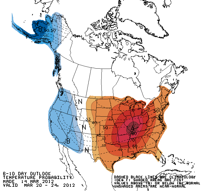 |
| 6-10 day temperature outlook. CPC |
 | |
| 8-14 day temperature outlook. CPC |
 |
| Temperature outlook for March. CPC |
Average Forecasted High For The Next 5 Days: 73°F
Normal High/Low for this time of year: 42°F/24°F
There is a good chance some records will be set.
Record Highs:
| March: | High | Year |
| 15 | 79 | 1990 |
| 16 | 80 | 1990 |
| 17 | 68 | 2003 |
| 18 | 67 | 1989 |
| 19 | 70 | 1966 |
Numbers from wunderground.com for Port Meadville Airport.
Forecasted High Temperatures for the next 11 days.
Smaller temperatures are AccuWeather Forecasted Highs.
| March: | High |
| 15 | 73 |
| 16 | 70 |
| 17 | 73 |
| 18 | 76 |
| 19 | 74 |
| 20 | 72 |
| 21 | 67 |
| 22 | 62 |
| 23 | 59 |
| 24 | 60 |
| 25 | 64 |
March 10, 2012
Jupiter & Venus Putting On A Show
If you've noticed two very bright objects in the sky at night you may wonder what stars they are. In fact, they aren't stars at all but actually two planets...Jupiter and Venus. Both stick out in the sky like a sore thumb in the Western sky because of their brightness and closeness to each other. On March 12 and 13, they will be only 3 degrees apart. Tonight is a great night to get a view of them as the skies are very clear. I went out and took a picture of them at sunset earlier tonight. Mars is also visible in the Eastern sky and has a reddish orange appearance. If you are lucky enough, you might be able to catch Mercury right at dusk on the horizon.
 |
| Jupiter left and Venus right with the sunset near Townville on March 10. |
Spring Ahead Saturday Night
Don't forget to "Spring Ahead" Saturday night by setting those clocks an hour ahead.


March 5, 2012
Spring Weather Pattern Setting Up?
 |
| March 10-14 temperature probability outlook. There is a really good chance that we will see above average temperatures. |
Week Outlook Summary:
Monday will be chilly as cold arctic air tries to creep southward into our area. Monday night will be cold as lows will drop into the teens. High pressure builds in for Tuesday & Wednesday allowing for mostly sunny skies and warmer temperatures. These will definitely be very nice spring like days so get out and enjoy them! A cold front will move through the area Thursday bringing showers with it (maybe even a rumble of thunder). Friday is looking partly cloudy with temperatures still above average.
Looks like spring is here :)
Many Picking Up The Pieces After Deadly Tornado Outbreaks
 |
| Tornado damage in Harrisburg, IL Source: http://www.flickr.com/photos/60464669@N06/6941893983 |
Check out the Enhanced Fujita rating system HERE.
| Confirmed Total | Confirmed EF0 | Confirmed EF1 | Confirmed EF2 | Confirmed EF3 | Confirmed EF4 | Confirmed EF5 |
| 36 | 6 | 15 | 13 | 1 | 1 | 0 |
Leap Day Tornado Outbreak Totals
Source: Wikipedia
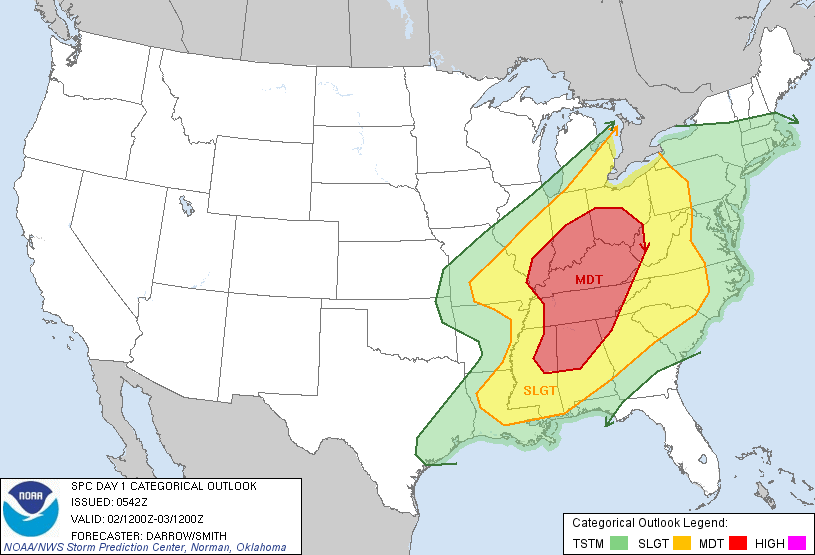
 The next day the Storm Prediction Center forecasted a high risk area for tornadoes in the Ohio & Tennessee River valleys. Many were predicting a larger and more devastating tornado outbreak to occur on Friday March 2....and it did.
On March 2nd, a low pressure system near Missouri was moving ENE with much of the OH & TN River valleys in the warm sector of the low. A strong low level jet stream was present bringing in moisture and warm air which was destabilizing the atmosphere. This created a great atmosphere for convection and thunderstorm development. Strong wind shear also was present. These two combined formed a great environment for tornadoes to develop.
 |
| Image of all the tornado (red) and thunderstorm (yellow) warnings issued on March 2nd. Source: WeatherMatrix.AccuWeather.com |
 | |
| "Hook echo" displayed on radar just west of West Liberty. This is the storm that produced the tornado that hit West Liberty. This radar image shows a textbook display of a "hook echo" which is a great indication of a tornado. Source: Wes Mason (Twitter) |
The death total for the outbreak stands at 39 right now and continues to rise each day. One of the deaths was a 14-month old girl who was found in a field still alive. She had been picked up by the tornado and carried in the air before she finally landed in a field. She died a couple days later after being taken off of life support.
This year is already proving to be a busy tornado season. Tornado season typically lasts from April to June so outbreaks this early are rare. The total count of tornadoes this year (excluding Feb 29, and March 2-3 outbreaks) is 128. The average number is around 50. Last year, which ended with the highest total over the last three years, saw 79 tornadoes occur before March. Below are tornado totals over the past three years and this year from the SPC
...NUMBER OF TORNADOES...    NUMBER OF       KILLER
                                    TORNADO DEATHS  TORNADOES
      ..2012.. 2011 2010 2009 3YR              3YR             3YR
    PREL  ACT  ACT  ACT  ACT  AV 12  11 10 09  AV  12 11 10 09 AV
JAN  95    -   16   30    6   17  2   0  0  0   0   2  0  0  0  0
FEB  33    -   63    1   36   33  7   1  0  9   3   2  1  0  2  1
MAR   -    -   75   33  115   74  -   1  1  0   1   -  1  1  0  1
APR   -    -  758  139  226  371  - 360 11  6 126   - 43  2  3 16
MAY   -    -  326  304  201  279  - 178  7  5  64   -  9  4  3  5
JUN   -    -  160  324  270  251  -   3 12  0   5   -  1  6  0  2
JUL   -    -  103  146  118  122  -   0  2  0   1   -  0  1  0  0
AUG   -    -   57   55   60   57  -   2  1  0   1   -  2  1  0  1
SEP   -    -   51   57    8   39  -   0  2  0   1   -  0  2  0  1
OCT   -    -   23  108   65   65  -   0  0  1   0   -  0  0  1  0
NOV   -    -   44   53    3   39  -   5  0  0   2   -  2  0  0  1
DEC   -    -   33*  32   38   34  -   0  9  0   3   -  0  4  0  1
    ---- ---- ---- ---- ---- ---- -- -- -- --- --- -- -- -- -- --
SUM  128   0 1709* 1282 1146 1382 9 550 45 21 206   4 59 21  9 30

PREL = 2012 PRELIMINARY COUNT FROM ALL NWS LOCAL STORM REPORTS.
ACT  = ACTUAL TORNADO COUNT BASED ON NWS STORM DATA SUBMISSIONS.
Remember, tornadoes are very dangerous and any warning should be taken seriously. One of the best ways to to stay safe during severe weather outbreaks is to purchase a weather radio! Weather radios can be bought at local wal-marts and online at various sites.
Sources:
http://www.spc.noaa.gov/climo/online/monthly/newm.html
http://www.weather.com/outlook/weather-news/news/articles/tornado-outbreak-march-reports_2012-03-02
http://edition.cnn.com/2012/03/04/us/indiana-tornado-girl/?hpt=us_c1
http://en.wikipedia.org/wiki/Early_March_2012_tornado_outbreak
http://en.wikipedia.org/wiki/2012_Leap_Day_tornado_outbreak
March 2, 2012
Severe Weather Outbreak Expected
It is the 2nd day of March and here we are talking about severe weather....
A severe weather outbreak is expected Friday across the Ohio & Tennessee River Valleys. For some, this is round 2. Wednesday many tornadoes rolled through the area leaving people dead, injured, and their homes destroyed. The bulk of the severe weather will be centralized in the OH & TN Valleys but the threat of severe weather extends into Northwestern PA. There is a chance that our area could see some nasty storms roll through in the evening. Strong winds, hail and lighting are definitely possible and an isolated tornado can't be ruled out, although it is unlikely. Make sure to monitor the weather throughout the day and be aware of any possible severe storms that could be moving through the area. Check back to CrawfordWeather.com for the latest updates on the severe weather. Follow us on twitter for updates as well.
 |
| Tornado probability for Friday NOAA SPC |
 |
| Severe thunderstorm risk for Friday NOAA SPC |
 | |
| Wind probability for Friday NOAA SPC |
Subscribe to:
Posts (Atom)