 |
| Rainfall totals from May 27th storm. Some places saw over an inch of rain in a short amount of time. Values from wunderground.com |

CrawfordWeather.com is Crawford County Pennsylvania's source for weather information!
May 27, 2012
Rainfall Totals From May 27th Storm
Here are some rainfall totals from around the region for the storms that rolled through our area May 27th.
Memorial Day Forecast

Past Memorial Day Weather (KGKJ - Port Meadville Airport)
Year High Low Weather
2011 87 63 Sunny
 2010 84 64 Thunderstorms
2009 75 51 Sunny
2008 79 55 Showers
2007 73 55 Partly Cloudy
Forecast for this year
2012 91 64 Mostly Sunny
PM T-Storm?
** Record high for May 28th is 88 set back in 1978. It looks like we will break that.
If you are tired of the heat already...there is a cool down coming later this week. More on that in a couple days.
May 25, 2012
NOAA Releases Hurricane Predictions
NOAA relased their annual predictions regarding the upcoming Atlantic Hurricane season, which runs June 1st to November 30th. They are predicting 9-15 names storms, of which 4-8 will become hurricanes. They expect 1-3 of those hurricanes to become major hurricanes, which requires a status of Category 3 or higher. Here are predictions from different people and places for the upcoming hurricane season.
Source: Wikipedia
Some are on there twice as they have made revisions throughout the last few months.
Hurricanes are classified on the Saffir-Simpson scale:
wind (mph)
Category 1: 74-95
Category 2: 96-110
Category 3: 111-129
Category 4: 130-156
Category 5: >= 157
The season hasn't officially began yet but there has already been one named storm: Alberto.
| Source | Date | Named storms |
Hurricanes | Major hurricanes |
|
| Average (1950–2000)[1] | 9.6 | 5.9 | 2.3 | ||
| Record high activity | 28 | 15 | 8 | ||
| Record low activity | 4 | 2 | 0† | ||
| ––––––––––––––––––––––––––––––––––––––––––––––––––––––– | |||||
| TSR | December 7, 2011[2] | 14 | 7 | 3 | |
| WSI | December 21, 2011[3] | 12 | 7 | 3 | |
| CSU | April 4, 2012[4] | 10 | 4 | 2 | |
| TSR | April 12, 2012 | 13 | 6 | 3 | |
| TWC | April 24, 2012 | 11 | 6 | 2 | |
| UKMO | May 24, 2012[5] | 10* | N/A | N/A | |
| NOAA | May 24, 2012 | 9-15 | 4-8 | 1-3 | |
| TSR | May 24, 2012 | 13 | 6 | 3 | |
Some are on there twice as they have made revisions throughout the last few months.
Hurricanes are classified on the Saffir-Simpson scale:
wind (mph)
Category 1: 74-95
Category 2: 96-110
Category 3: 111-129
Category 4: 130-156
Category 5: >= 157
The season hasn't officially began yet but there has already been one named storm: Alberto.
May 22, 2012
Summer Like Temperatures For End of Week and Weekend.

| High Temps °F |
Record °F |
|
| Thursday | 84 | 88 |
| Friday | 86 | 87 |
| Saturday | 85 | 85 |
| Sunday | 87 | 85 |
| Avg High | 85.5 |
Here is the GFS MOS temperatures for the next 7 days along with the normals for Wednesday.
     WED 23| THU 24| FRI 25| SAT 26| SUN 27| MON 28| TUE 29|WED CLIMO
 N/X  53  77| 60  83| 62  84| 60  83| 65  87| 65  86| 63  76| 56 48 72
The GFS and Euro model both have our area close to the 90 degree contour for Sunday. I wouldn't be surprised if we came close or hit 90.
 |
| 18 Z Sunday Euro model of temps: Light purple are 90s while dark purple is 80s. |
 |
| 18 Z Sunday GFS model of temps: Light purple are 90s while dark purple is 80s. |
May 20, 2012
Saturday's Chase Recap
 |
| Panoramic view of the approaching storm and its structure. A tornado warning was issued right after this was taken. |
 |
| The two cells we were chasing. The white square is where we were located and the white circle was where somebody reported seeing a tornado a few minutes after we saw one. |
.JPG) |
| Mammatus clouds to the south west of the cells. |
May 19, 2012
Chase Time

Follow updates at @CrawfordWeather on twitter and facebook.
Track us live at live.stormtrackerwx.com
Upgraded Risk
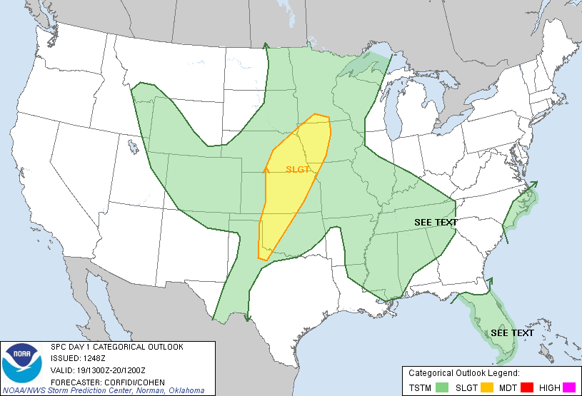
 |
| Tornado outlook. |
May 18, 2012
Partial Solar Eclipse Sunday
 |
| A partial eclipse will be viewable from Crawford County. Credit: Bob King |
Even though the best viewing for the solar eclipse is in the west, back here in Crawford County you'll be able to see a partial eclipse. It will occur in the late evening towards sunset on Sunday so the sun will be very low on the horizon. The eclipse will be very small. It is advised not to ever look directly into the sun as this can lead to health problems.
 |
| Generally clear skies will give viewers a good shot of seeing the partial eclipse. |
Day 2
 |
| Driving through Kansas City |
 |
| We will be mainly focusing on the central and southern KS area. |
May 17, 2012
On The Road
 |
| Friday's severe outlook. |
 |
| Saturdays severe outlook. |
Remember to track us live at StormTrackerWx.com and to follow us on Facebook and twitter.
 |
| We have decided to rest up in St.Louis. |
May 16, 2012
Weekend Outlook

Frost Advisory Issued Overnight
The National Weather Service in Cleveland has issued a frost
advisory...which is in effect from 2 am to 8 am EDT Thursday.
Temperatures are expected to drop into the lower to mid 30's
for most of the area tonight. These low temperatures will
threaten outdoor vegetation so take any outdoor plants
inside or cover them up if you can.
Pleasant Days Ahead
The next 5 days are looking very nice! Other than a slight chance of a passing shower Wednesday afternoon, the next 5 days look pleasant with mild temperatures and plenty of sun. This is due to an upper level ridge that will be providing the eastern US with great weather.
Storm Chase Delayed
The storm chase has been delayed until Thursday. This is due to a fairly quiet weather pattern that has set up across the United States. A large ridge has been in place which is damping down any shortwaves moving across the western US into the plains. However, Saturday is looking decent for storm development in the northern plains. A shortwave is looking to move through along with a deepening low pressure system. A low level jet is expected to develop ahead of the cold front which will advect gulf moisture up through the plains and fuel any type of storm development. Here is some of the forecast discussion for the northern plains:
MORE IMPRESSIVE UPPER WAVE AND ASSOCIATED COOL FRONT PUSH INTO THE
REGION FOR THE UPCOMING WEEKEND...WITH MODELS CURRENTLY SHOWING
FAIRLY DECENT AGREEMENT ON TIMING OF THESE FEATURES. THIS WILL BRING
THE COOL FRONT INTO THE FAR WESTERN CWA EARLY SATURDAY...AND HAVE
SOME LOW POPS LATE FRIDAY NIGHT AS THE LEAD WAVE LIFTS NORTHEAST
ALONG THE BOUNDARY. CURRENT TIMING HAS FRONT PUSHING THROUGH OUR SD
COUNTIES DURING THE DAY/EARLY EVENING...SITTING BETWEEN THE JAMES
VALLEY AND I-29 BY 00Z SUNDAY. WITH A LITTLE BETTER SHEAR RIGHT
ALONG THE BOUNDARY AND MODEST INSTABILITY IN WARM/INCREASINGLY MOIST
AIRMASS AHEAD OF THE BOUNDARY...WOULD NOT BE SURPRISED TO SEE
ISOLATED SEVERE THREAT LATE SATURDAY AFTERNOON/SATURDAY NIGHT.
GREATER CONCERN MAY BE LOCALLY HEAVY RAIN IN EASTERN PARTS OF THE
CWA SATURDAY NIGHT...AS SOUTH-SOUTHWEST LOW LEVEL JET PARALLEL TO
THE BOUNDARY AND MID-UPPER LEVEL FLOW COULD LEAD TO TRAINING OR
BACK-BUILDING OF STORMS.
This has given the StormTrackerWx team some hope for chasing some storms so we have decided to set out Thursday morning for the Dakotas. We are hoping to run into some severe weather out there so wish us luck! Remember to follow StormTrackerWx on facebook, CrawfordWeather.com on facebook, CrawfordWeather on twitter, and to check out the CrawfordWeather.com Blog for more details and updates as we progress through our trip. You can watch us LIVE on StormTrackerWx.com as well!
May 10, 2012
"Supermoon" Lights Up The Sky.
 |
| Picture I took of the "supermoon" outside of Townville. I caught it just as it began to rise above the treeline. |
Click to view the slideshow.
Slideshow (at the bottom of the page):
Storm Chasing Event Coming Up
Anybody can follow this week long event. Jason has launched StormTrackerWx.com, a website that is meant for our chasing. You can follow us and watch us as we stream live video. Live video streaming will give you the opportunity to see what we see! You can also follow our adventures as we will be blogging throughout the week. Make sure to check out the StormTrackerWx Blog. Also, both mine and Jason's twitter accounts will be active and we will be tweeting a good amount. That is another great way to keep track of us and the action. More details will surface as we get closer to the chasing date so stay tuned!
-----------------------------------------------------------------------------------------------------------
Storm Chasing
The official starting date has been pushed back to Wednesday May 16 due to unfavorable weather.
May 16th - 23rd
Follow the chase at StormTrackerWx.com!
Live Streaming Video (Have to sign-up... It is free!)
Follow the chase team: StormTrackerWx Blog
CrawfordWeather.com Blog
Jason's Twitter: @TrackTheStorm
Jordan's Twitter: @CrawfordWeather
Don't miss out on the chase!
Weekend Outlook

May 3, 2012
"Supermoon" Will Shine This Weekend
The moon will make its closest approach to the earth this weekend and will also be in its full stage. The "Supermoon" will become full Saturday at 11:35 p.m but will be great to observe days before and after as well.
April Ends Dry, Will May Be The Same?
 |
| Currently there are no drought conditions for western PA but if the dry weather continues, expect that to change. Credit: U.S. Drought Monitor |
Subscribe to:
Posts (Atom)