July 28, 2012

Cold Air Funnels

Some funnel clouds were sighted today.  We weren't under normal severe weather and tornadic conditions today so why were these funnels forming?

Radar from earlier when the Tornado Warning
was issued. 
Image: Plymouth State University
These funnels are actually called Cold Air Funnels and form when there is very cold air aloft, and a low pressure system in the area.  They are usually short-lived and form from weak showers/storms.  They can touch down briefly but usually are very weak and produce little to no damage.

18 Z HPC Surface Analysis.
Notice the low situated over the OH, PA border.
Today's weather has created a favorable environment for  cold air funnels to develop.  With cold air aloft moving in from the north, and a low pressure system situated just over our area, this allowed for some thunderstorms to develop and for some cold air funnels to also be formed.  The location of the low pressure system is key because this is what helps create the "spin" in the atmosphere and for funnels to develop off of it.

Interested In Storm Chasing?


Has storm chasing always been something you've wanted to do?  Well now is your chance! StormTrackerWx is now accepting applications for a weeks worth of storm chasing next June.  WJET-TV Meteorologist Jason Berry, founder of StormTrackerWx, has started up StormTrackerWx Tours and is looking for anybody who would like to head out for a week west of the Mississippi to chase natures most violent storms.  Head to the StormTrackerWx Tour page for more details.

It'll definitely be a great experience!  Jason and I headed out to Kansas and Nebraska in mid May and stormed chased for a few days.  It was definitely an experience that I enjoyed and I'm looking forward to going next year!  So if you are somebody who enjoys the weather and frequent adrenaline rushes, well this is your opportunity.  Not many people can say they professionally chased tornadoes.

Approaching storm in southern Nebraska, taken in mid May when Jason and I were storm chasing.

July 26, 2012

Dought Monitor July 24th

Here is the updated drought monitor.  Nothing has changed since the last drought monitor.  Much of Crawford County is under a "moderate drought".  However, the recent rain definitely helped and there is more in the forecast for Friday and Saturday. 

Thursday's Severe Weather

Storms moved through around 5 & 6 AM Thursday morning.
Radar image at 5 AM.
Plymouth State
The second round of storms began around 2 PM.
A line of severe storms pushed through the county
and took down some trees, leaving many in the dark.
At one point, a tornado warning was issued but
nothing was reported or spotted.
Radar image at 2 PM.
Plymouth State.

Power outages earlier today. Much of Eastern Crawford
was left in the dark after the storms rolled through.
Franklin and Oil City areas were also hit hard.
Well, as forecasted, Thursday turned out to be an eventful day. Storms moved through early Thursday morning around 5 & 6 AM but were not as strong as initially feared. They lost much of their energy due to overnight cooling of the surface and didn't really pack too much of a punch as they went through.  That wasn't really the big concern for the day though. What forecasters had on their mind was the approaching warm front and developing low level jet that would intensify during the afternoon hours. With mainly cloudless skies, many locations across PA warmed up quickly in the morning hours and a southerly flow pumped dew points into the lower 70s.  Two things that storms feed off of, high dew points and warm surface temperatures, helped set up a severe weather scenario for much of the state.  It wasn't no surprise when a line of storms began to form around 1 and 2 PM in NE OH.  As these storms moved through, they took down a few trees around the county and even put many people in the dark.  A wind gust of 70 mph was reported in Jamestown, PA...according to AccuWeather. CrawfordWeather.com lost many graphics and pages due to the 5 hour power outage in the Townville area.  Many people east of Meadville were without power for much of the afternoon.  These storms also showed signs of rotation and at one point a tornado warning was issued for Southern Crawford County, based off of radar indicated rotation (no funnels or tornadoes were ever reported or confirmed in Crawford County). However as this storm moved into Venango County, it took down many more trees along its path, especially in the Franklin and Oil City area. A wind gust of 48 mph was reported at the airport near Franklin around 2:15 PM. Later on it would produce a funnel cloud and even a possible tornado in the Brookville area.  Still waiting to hear confirmation on that one.  This line would continue on through Pennsylvania causing havoc in many other areas, knocking down trees, and causing power outages. 

Power outages for Penn Power, Penelec at 11 PM Thursday
night. Any county in color is experiencing outages.
Penelec
According to the SPC Storm reports page, only one tornado was officially confirmed. That one occurred in Southern NY, near the PA border.  The one in Brookville has yet to be confirmed.  All in all it was an eventful day.  I think forecasters got this one right by putting our area in a moderate risk for severe storms.  All these storms started in NE OH and NW PA and caused destruction all the way to the Atlantic Ocean. Many people still do not have power across Pennsyvlania. Pretty crazy day.  Looking on the better side of today, at least we got some rain to help lessen the drought.


SPC Storm Reports.  Many places experienced gusty winds
while one tornado was officially confirmed in Southern NY.

Left In The Dark For Many

Update: (7:30 PM)  Power is being restored to some areas.  The graphics and advisory page are working now.  

Many people in the county are currently without power.

Here is the latest power outage map from Penelec and NW REC.

Also due to power outages, many graphics on CrawfordWeather.com and the advisory page are down.

Penelec power outages.

REC power outages.

July 25, 2012

Severe Weather Likely Thursday

Severe weather is expected to occur across much of the area tomorrow. The SPC has issued a moderate risk and Crawford County is on the edge of it.  In terms of severe weather, a moderate risk isn't issued very often so this is something to consider.  A derecho is expected to form and will bring strong winds to whoever is in its path.  Here is what the SPC is saying....

SPC:

"POTENTIAL FOR A WIDESPREAD DAMAGING WIND EVENT/DERECHO ON THU AFTERNOON FROM PARTS OF THE MIDWEST TO THE NORTHEAST..."
"CONFIDENCE CONTINUES TO GROW WITH POTENTIAL FOR SCATTERED TO NUMEROUS ORGANIZED SEVERE TSTMS...PARTICULARLY FROM THE MIDWEST TO THE NORTHEAST."


As of right now, there seems to be "two" severe weather events for Thursday.  The first one will occur in the morning hours somewhere just before sunrise.  This one is interesting. Earlier the models had a derecho/large bow echo moving through our region but the newer models have actually weakened it and moved it up towards Buffalo, putting us out of the way.  However, there are still storms that will affect our area at that time, but hopefully winds will not be as big of an issue as I feared earlier with the bow moving through.

The other event will be in the aftenroon/evening when the cold front begins to work its way through our region.  Daytime heating, large temperature gradient along the front, and a strong low level jet will help fuel thunderstorm development.  These have the chance to be pretty nasty so watch out.  Strong winds, hail, and even an isolated tornado are possible as these storms begin to pop up.   

Make sure to check back here for more updates about this severe weather event.  I'll keep you posted today and tomorrow of any possible severe weather threats.  Always take a look at our advisories page for any weather watches and warnings that are issued.

July 19, 2012

Much Needed Rain Today

We recieved some much needed rain a little bit ago.

Here are the rain totals from the showers/storms that pushed through.


Image from Wunderground

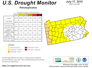
Updated Drought Monitor

Here is the July 17th updated drought monitor. 
Over half of Crawford County is in a "moderate" drought while some of the eastern portion is considered "abnormally dry".  Either way, water should be conserved for those who have wells. 

So how dry are we?  In terms of precipitation, we are running well below normal.  Currently Port Meadville Airport stands at 1.80 inches and the average for the month is 4.27 inches.  June saw 3.15 inches while the average for the month was 4.14 inches.  May and April were also below normal and the lack of snowfall this past winter has also hurt our region.  Hopefully there will be some relief soon or else we might not have seen the worst of it yet. 

July 11, 2012

Townville Old Home Days Forecast

The 43rd Townville Old Home Days celebration will be happening this Friday and Saturday at Maplewood Elementary School.  I'll be forecasting the weather for both days.  I'll be issuing a general forecast, a 5K race forecast, and of course the parade forecast which is Saturday morning.


July 6, 2012

Drought Conditions

The most recent drought monitor release has most of Crawford County under a "Moderate Drought". 


July 5, 2012

Your Weekend Outlook

Hello Crawford County, here is your weekend outlook....


Saturday is shaping up to be a pretty decent day.  The heat will still be around and there will be a slight chance for some thunderstorms during the day but not a washout.

Sunday is still a little unsettled in terms of the forecast. As of right now, it is looking mainly sunny with a slight chance of a t-storm.  The precip chance may change as we get closer and I'll update this tomorrow and see where we stand but right now it is looking like a good day.  Temperatures will be noticeably cooler as highs are only forecasted to be in the lower 80s.  This is a big difference from the upper 80s and lower 90s we have been seeing over the last few days.

July 2, 2012

June Summary & July Outlook

The month of June flew by! It was an average month when talking about temperatures. The average high for Meadville in June is 76° with an average low of 56°.  This past one saw an average high of 78° and an average low of 58°.  Precipitation was below average with a total of 3.15 inches.  The average was 4.75 inches.


June 2012 Summary
Avg High (°F) Avg Low (°F) Total Precip (in)
78 58 3.15


Average Values
Avg High (°F) Avg Low (°F) Total Precip (in)
76 56 4.75


Difference
Avg High (°F) Avg Low (°F) Total Precip (in)
2 2 -1.60


Temp outlook for July issued by the CPC.  According to them
we have a 33% chance of seeing above average temps.
Source: CPC
July is expected to be a bit warmer than average. The average high in July is 80° while the low is 60°. Expect the late June heat to continue into July.  In terms of precip, it is expected to be an average July which is 4.26 inches of rain. 

Precip outlook for July issue by the CPC.  According to
them, we have equal chances of seeing above, below
and at normal values.


Snowfall Totals 2011-2012

Snowfall totals for 2011-2012 winter.
Data source: NWS Cleveland
Too hot for ya? Here is some news that will get you thinking cooler weather, I've got the 2011-2012 snowfall totals around the area that were released by the NWS Cleveland.  Numbers were way down this year which is no surprise.  Everybody knew that we experienced a mild winter that lacked our normal snowfall amounts.  Below is the summary that the NWS wrote about the winter.

  
Winter 2011-2012 (Northern Ohio, Northwest Pennsylvania).\

Winter? What winter?

Snowfall 2011-2012
Source: NWS Cleveland
We started out the winter with a warm November and December, and then it just got warmer. Cold spells were brief, usually about once a week, and often on the weekend. It would snow a little and there was some wind, which made it feel colder than it really was. Then a day or two later it was 40+ degrees again. There were a few lake effect snows, January 2nd and January 14th and again on February 11th. Overall, snow for the season was well below normal.
The winter ended with unprecedented warmth in March leading to a very early spring (80+ degrees in March!). March became the warmest month on record relative to normal (13 degrees above normal at Cleveland). April got chilly but temperatures and snowfall were actually near normal. It seemed colder than March and in fact it was - the average temperature in April was colder than March! 

Precipitation decreased through the winter and it was rather dry in many areas by late Spring.

Source: NWS CLEVELAND. 


Seasonal snowfall last year.  Big difference compared to
this past year.
Source: NWS Cleveland

Snowfall totals two years ago ( 2009-2010. )
Source NWS Cleveland.
 If you are looking for snowfall information, there is a great place to find it.  Click here.

I kept snowfall measurements for Townville this year. That data can be seen by clicking here.

Fourth Forecast

Fourth of July is looking partly cloudy with a chance of a thunderstorm. It won't be a washout kind of day but there is a chance of some precip which could interrupt any picnics or other outdoor activities that might be going on.  In terms of temperature, it'll be another warm one with highs in the upper 80s and some areas could end up in the lower 90s.


Upcoming Firework Displays

July 3rd
Oil City
Dusk

July 4th
Riverside Inn Cambridge Springs
9:30 PM

Country Club North of Meadville on Rt 86
At Dusk

Franklin
Dusk

July 7th
Conneaut Lake
9:45 PM
**According to Facebook