November 29, 2012

Weather Outlook

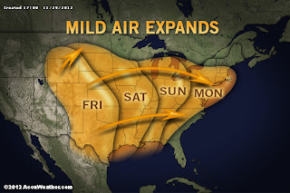
Milder temperatures will move in over the weekend
and into Monday.
Photo Credit: AccuWeather
  
After our small and kind of disappointing lake effect snow event last weekend, things have quieted down.  As the week comes to an end and the weekend begins to fall upon us, the weather pattern is looking fairly quiet with no large systems impacting our region in the near future. Friday there is a slight chance that our region could see a little bit of snow/rain mix.  However right now it appears that most of the region will remain dry.  Saturday will start out as dull but skies will clear towards evening.  Temperatures will be gradually warming starting Saturday.  Sunday a weak front will move through with only a chance for scattered rain showers. Temperatures will still be above average.  Monday is looking unseasonably warm for the area and should be a decent day with some sun.  Tuesday is when a stronger front makes its way through the region bringing with it some scattered rain showers.  Behind it will be colder air that will bring temperatures back down to normal and slightly below normal. A few snow showers could spark up Wednesday but as of right now it appears to be minimal.

Looking even farther ahead, warmer temperatures appear to move back in late week and into the weekend out ahead of a front.  However the front is expected to move through towards late weekend and behind it we could see a strong lake effect snow event. Realize it is over a week away and things are likely to change but just a heads up.


Watch The 2012 Atlantic Hurricane Season in 4.5 Minutes!

Here is a video of the 2012 Atlantic Hurricane Season.  A little over a half of a years worth of weather compiled into a 4.5 minute video. Neat!


November 23, 2012

Snowy Weekend In Store For The Region

Looks like we will be seeing our first significant lake effect snow event this weekend.  Snow will start to fall tonight (Friday night) and will finally let up Sunday morning.  The heaviest will be in the snowbelts (North and NE Crawford County).  Here are the forecasted snowfall accumulations.

http://sphotos-a.xx.fbcdn.net/hphotos-prn1/62272_448588081864704_27535237_n.jpg
Make sure to check out snowfall report page for official snowfall totals.  You can also send in snowfall reports on there as well.

November 4, 2012

Nor'easter Update

It appears that coastal storm I mentioned a few days ago will have little affect on our region.  It will brush just east of the NJ coast and move NE with the precipitation well to our east.  Areas in the PA Appalachians could see some snowfall but farther east will see heavy rain and gusty winds.  Unfortunately, it appears New York City is under the gun again and with clean-up efforts still underway there is no question that this storm will just add to the problems.  This kind of weather pattern is expected through November and possibly into December.  Expect more Nor'easters.


Euro model showing the nor'easter at 8AM
Thursday.  Colors are precipitation.
GFS model showing nor'easter at 8 AM
Thursday.  Colors are precipitation.