 |
| Rainfall totals from May 27th storm. Some places saw over an inch of rain in a short amount of time. Values from wunderground.com |

CrawfordWeather.com is Crawford County Pennsylvania's source for weather information!
May 27, 2012
Rainfall Totals From May 27th Storm
Here are some rainfall totals from around the region for the storms that rolled through our area May 27th.

Memorial Day Forecast


Past Memorial Day Weather (KGKJ - Port Meadville Airport)
Year High Low Weather
2011 87 63 Sunny
 2010 84 64 Thunderstorms
2009 75 51 Sunny
2008 79 55 Showers
2007 73 55 Partly Cloudy
Forecast for this year
2012 91 64 Mostly Sunny
PM T-Storm?
** Record high for May 28th is 88 set back in 1978. It looks like we will break that.
If you are tired of the heat already...there is a cool down coming later this week. More on that in a couple days.
May 25, 2012
NOAA Releases Hurricane Predictions
NOAA relased their annual predictions regarding the upcoming Atlantic Hurricane season, which runs June 1st to November 30th. They are predicting 9-15 names storms, of which 4-8 will become hurricanes. They expect 1-3 of those hurricanes to become major hurricanes, which requires a status of Category 3 or higher. Here are predictions from different people and places for the upcoming hurricane season.
Source: Wikipedia
Some are on there twice as they have made revisions throughout the last few months.
Hurricanes are classified on the Saffir-Simpson scale:
wind (mph)
Category 1: 74-95
Category 2: 96-110
Category 3: 111-129
Category 4: 130-156
Category 5: >= 157
The season hasn't officially began yet but there has already been one named storm: Alberto.
| Source | Date | Named storms |
Hurricanes | Major hurricanes |
|
| Average (1950–2000)[1] | 9.6 | 5.9 | 2.3 | ||
| Record high activity | 28 | 15 | 8 | ||
| Record low activity | 4 | 2 | 0† | ||
| ––––––––––––––––––––––––––––––––––––––––––––––––––––––– | |||||
| TSR | December 7, 2011[2] | 14 | 7 | 3 | |
| WSI | December 21, 2011[3] | 12 | 7 | 3 | |
| CSU | April 4, 2012[4] | 10 | 4 | 2 | |
| TSR | April 12, 2012 | 13 | 6 | 3 | |
| TWC | April 24, 2012 | 11 | 6 | 2 | |
| UKMO | May 24, 2012[5] | 10* | N/A | N/A | |
| NOAA | May 24, 2012 | 9-15 | 4-8 | 1-3 | |
| TSR | May 24, 2012 | 13 | 6 | 3 | |
Some are on there twice as they have made revisions throughout the last few months.
Hurricanes are classified on the Saffir-Simpson scale:
wind (mph)
Category 1: 74-95
Category 2: 96-110
Category 3: 111-129
Category 4: 130-156
Category 5: >= 157
The season hasn't officially began yet but there has already been one named storm: Alberto.
May 22, 2012
Summer Like Temperatures For End of Week and Weekend.

| High Temps °F |
Record °F |
|
| Thursday | 84 | 88 |
| Friday | 86 | 87 |
| Saturday | 85 | 85 |
| Sunday | 87 | 85 |
| Avg High | 85.5 |
Here is the GFS MOS temperatures for the next 7 days along with the normals for Wednesday.
     WED 23| THU 24| FRI 25| SAT 26| SUN 27| MON 28| TUE 29|WED CLIMO
 N/X  53  77| 60  83| 62  84| 60  83| 65  87| 65  86| 63  76| 56 48 72
The GFS and Euro model both have our area close to the 90 degree contour for Sunday. I wouldn't be surprised if we came close or hit 90.
 |
| 18 Z Sunday Euro model of temps: Light purple are 90s while dark purple is 80s. |
 |
| 18 Z Sunday GFS model of temps: Light purple are 90s while dark purple is 80s. |
May 20, 2012
Saturday's Chase Recap
 |
| Panoramic view of the approaching storm and its structure. A tornado warning was issued right after this was taken. |
 |
| The two cells we were chasing. The white square is where we were located and the white circle was where somebody reported seeing a tornado a few minutes after we saw one. |
 |
| Mammatus clouds to the south west of the cells. |
May 19, 2012
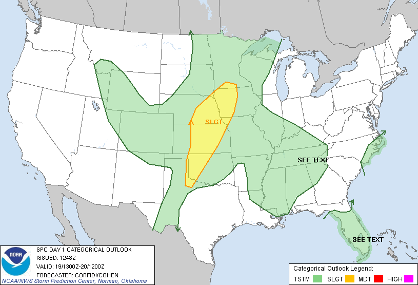
Chase Time

Follow updates at @CrawfordWeather on twitter and facebook.
Track us live at live.stormtrackerwx.com
Upgraded Risk
 |
| Tornado outlook. |
Subscribe to:
Posts (Atom)