 |
| Graphic of area wind gusts. Yellow numbers indicate official airport data. White numbers are personal weather stations. Data is from wunderground.com. Values are in mph. |

CrawfordWeather.com is Crawford County Pennsylvania's source for weather information!
February 25, 2012
Friday's Wind Gusts
February 22, 2012
Up & Down Weather Pattern Heading Into The Weekend

Meteorological winter runs until the end of February and with only a week left, this winter will probably end as one of the warmest for many cities across the U.S. READ ARTICLE
February 18, 2012
Mild and Below Average Snowfall Summarizes Winter Season So Far
What a crazy winter season it has been. What started out in the Fall as a forecasted cold and snowy winter has been nothing of the sort thus far and has Meteorologists scratching their heads. The NAO has remained positive throughout the winter which has prevented the blocking of cold air. The cold air has not been able to stick around for long periods and there really hasn't been much cold air in general. I think roller coaster is a great description of the winter in our region so far. For most of December and January we experienced warmer days with rain, followed by colder air and snow. The position of the JET Stream is to blame for this weather pattern. Towards late January we hit a calm stretch but recently the JET Stream has developed a more meridional flow which is again creating that roller coaster weather pattern.
This winter has been above average in temperatures and below average in snowfall. The average temperature departure from the observed highs and normal high through the months of November and January show that we are running about 5°F above normal. The same can be said about the low temperatures. They are running about 6°F above normal. So it is no lie, this winter running a little warm.
The closest location with snowfall records is Erie which is recorded by the NWS in Cleveland. Clearly we have not had as much snow this year and the NWS data can confirm this. Data shows that Erie is running 28.9 inches below normal for this time of the year. I don't have snowfall data for Meadville but I do record it for Townville. Total snowfall for this winter for Townville is 70.7 inches. This is my first year keeping records so I have nothing to compare it too but I would have to assume that this is below normal.
The above average temperatures look to continue into next month. The Climate Prediction Center is saying that our region will likely experience above average temperatures for the month of March as well as above average precipitation. That precipitation however will most likely be in the form of rain so snow totals will likely continue to suffer. Even the three month outlooks show above average temperatures and precipitation. It looks like this trend will continue into spring as well.
 |
| Plot showing the 2011-2012 Average High Temperature and the Normal High each month for Meadville, PA. Average monthly high temperatures have been above normal in this winter season so far. |
 |
| Plot showing the 2011-2012 Average Low Temperature and the Normal Low each month for Meadville, PA. Average monthly low temperatures have been above normal in this winter season so far. |
| MEADVILLE AVERAGE MONTHLY TEMPERATURE | ||||||
| Normal (°F) | Observed Avg (°F) | Departure (°F) | ||||
| High | Low | High | Low | High | Low | |
| Nov 2011 | 48 | 33 | 54 | 38 | 6 | 5 |
| Dec 2011 | 36 | 23 | 40 | 29 | 4 | 6 |
| Jan 2012 | 31 | 17 | 36 | 23 | 5 | 6 |
| Feb 2012 | 34 | 17 | - | - | - | - |
| Mar 2012 | 43 | 24 | - | - | - | - |
| Apr 2012 | 57 | 36 | - | - | - | - |
 | |
| Plot of the 2011-2012 winter snowfall, the average snowfall, and last years snowfall for each month for Erie, PA. This year has been below average in terms of monthly and total snowfall. |
| ERIE SNOWFALL | ||||
| Month/Year | Observed | Average | Departure | Last Year |
| (inches) | (inches) | (inches) | (inches) | |
| Nov 2011 | 0.8 | 7.8 | -7.0 | 0 |
| Dec 2011 | 9.2 | 27.8 | -18.6 | 12.7 |
| Jan 2012 | 26.5 | 29.8 | -3.3 | 21.5 |
| Feb 2012 | 17.3 | 35.7 | ||
| Mar 2012 | 11.2 | 14.8 | ||
| Apr 2012 | 2.3 | 2.0 | ||
| TOTALS | 36.5 | 96.2 | -28.9 | 86.7 |
The above average temperatures look to continue into next month. The Climate Prediction Center is saying that our region will likely experience above average temperatures for the month of March as well as above average precipitation. That precipitation however will most likely be in the form of rain so snow totals will likely continue to suffer. Even the three month outlooks show above average temperatures and precipitation. It looks like this trend will continue into spring as well.
 |
| March temperature outlook. Image: Climate Prediction Center |
 |
| March precipitation outlook. Image: Climate Prediction Center |
 | ||
| March, April, and May temperature outlook. Image: Climate Prediction Center |
 |
| March, April, and May precipitation outlook. Image: Climate Prediction Center |
February 12, 2012
Skywarn Spotter Training Dates Announced
 |
| Skwarn spotter card that enables you to report severe weather events to the NWS. |
I was able to attend the one in Erie last year. It was my first time attending a Skywarn Session and I was impressed. Gary Garnet, a meteorologist at the NWS in Cleveland gave a presentation on severe weather and spotting techniques. The presentation was great and very informative. I encourage everybody to attend a session. It is a great experience and I guarantee you will walk out of there with more knowledge of the weather. The best part about Skywarn is that it is free and open to anybody. You also get the opportunity to sign up to become a spotter which enables you the chance to report any severe weather to the NWS. Because they are in Cleveland and cannot be present every time severe weather occurs, they rely on their Skywarn spotters heavily for severe weather reports. Everything is free and anybody can sign up.
Crawford County Skywarn
Thursday March 22, 2012 6:30 PM
St. Brigids Church
383 Arch Street
Meadville, PA 16335
MAP
Erie County Skywarn
Tuesday March 27, 2012 6:30 PM
Hamot Hospital
Hamot Hospital Audtorium
201 State Street Erie, PA 16550
MAP
Go To The NWS Cleveland Skywarn Website
February 10, 2012
Chilly Air & Snow Highlight The Weekend
 |
| NAM total liquid precipitation up through Monday morning. Liquid water equivalents show roughly 4" to 10" for the area. |

As for early next week, high pressure will dominate the region with mostly sunny skies Monday. Another system will move through Tuesday bringing more snow to the area.
 I'll have updated snowfall forecasts tomorrow so make sure to check back.
February 6, 2012
Rare Activity in the Gulf
 | |
| Track of the Groundhog's Day Tropical Storm in 1952. This has been the only tropical storm in the month of February since records have been kept. |
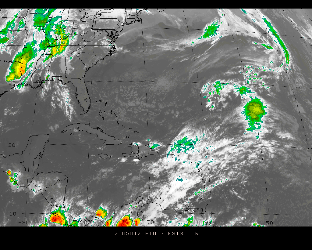 |
| IR image from PSU e-Wall. |
The hurricane season officially runs from June to November but it is not unlikely to get storms outside of these months. However, it is typically rare to see one in February. If this thing develops into a tropical storm, it will acquire the name Alberto, which is first on the 2012 name list.
UPDATE: 4:30 PM Feb 6
The National Hurricane Center is saying there is a 0 percent chance of further development with this system so looks like Alberto will have to wait.
February 4, 2012
Colder Air On Its Way
 |
| The positive phase on the left with the negative phase on the right and their affects to local weather. Wikipedia |
Arctic Oscillation
North Atlantic Oscillation
February 3, 2012
Nice Days Ahead

February 1, 2012
High Temperatures For Tuesday January 31st
Here are the local highs for Tuesday when unseasonably warm air made its way into the region. Meadville's record was 58° and the official airport reading came up 2° short. Erie fell short of its record as well.
 |
| High temperatures across the region Tuesday. White numbers are official airport readings. Meadvilles record: 58°, Erie's record: 63°. Neither were broken. Temperatures taken from area PWS & Airports. |
Night Sky Gazing
Clear cold nights are best for viewing the night sky and discovering the wonderful constellations and planets that are all around us. Now that we are in February, those clear & cold nights will be happening more frequently so it is time to be aware of what you are looking at! There are many neat constellations worth checking out this time of year and I've created a list of a few of them.

Orion
- Known as "The Hunter"
- Some say he is holding a lion, a shield, or a bow in one hand.
- Other hand has a club or a sword.
- Most popular for "Orion's Belt"
Where & When: Look just south of the center of the sky around 8-9 PM...progresses through sky from sunset to early morning.
The Famous Dippers....
Ursa Major & Minor ("The Big & Little Dipper")
Ursa Major is latin for "Larger Bear" and is widley known for "The Big Dipper" which is part of the constellation Ursa Major. Many believe the constellation looks like a bear with the tail being what many know as the big dipper. Once you find the big dipper in the sky, finding the rest of the constellation is fairly easy. Look for the legs! They are the easiest.
 Ursa Minor is Latin for "Little Bear", widely known as "The Little Dipper" and is sometimes hard to see at night, depending on where you live. The stars can appear a little faint to the eye and many city lights typically make it really hard to see. At the end of the little dipper is Polaris, the north star. It is NOT the brightest star in the night sky but is typically easy to find. The two end stars of the bowl of the big dipper point to Polaris and from there you can look for the rest of the constellation.
Where & When: Look to the north central part of the sky around midnight/1 AM for the best viewing. They can be seen through most of the night.

Cassiopeia
Fairly easy constellation to find in the sky due to its "W" shape. Not to far away from the dippers in the sky.
Where & When: See the dippers above.
 Canis Major
Latin for "Greater Dog" and is known as the dog constellation. Biggest feature is the star "Sirius" which is the brightest in the night sky. It serves as the dog's nose. This star is very noticable in the sky due to its brightness. Easy way to find it though is to follow the direction Orion's belt is pointing. It will lead you right to it. The star has also been called the "Rainbow Star" due to it's frequent flickering appearance.
Sick of constellations? Ah....interested in Planets?
Venus can be seen in the western sky at dusk until a a couple hours after sunset. Venus is very bright and is hard to miss.
Jupiter is also very bright and can be seen until around midnight. It is fairly close to the moon and is pretty easy to spot. If you have a powerful telescope, you should be able to zoom in on it and see its moons.
Mars is rising around 8 PM in the Eastern sky and can be seen throughout the night. It has a red/orange glow to it.
Saturn can be seen rising in the Eastern sky and hanging around the south central part of the sky most of the night.

Orion
- Known as "The Hunter"
- Some say he is holding a lion, a shield, or a bow in one hand.
- Other hand has a club or a sword.
- Most popular for "Orion's Belt"
Where & When: Look just south of the center of the sky around 8-9 PM...progresses through sky from sunset to early morning.
The Famous Dippers....
Ursa Major & Minor ("The Big & Little Dipper")
Ursa Major is latin for "Larger Bear" and is widley known for "The Big Dipper" which is part of the constellation Ursa Major. Many believe the constellation looks like a bear with the tail being what many know as the big dipper. Once you find the big dipper in the sky, finding the rest of the constellation is fairly easy. Look for the legs! They are the easiest.
 Ursa Minor is Latin for "Little Bear", widely known as "The Little Dipper" and is sometimes hard to see at night, depending on where you live. The stars can appear a little faint to the eye and many city lights typically make it really hard to see. At the end of the little dipper is Polaris, the north star. It is NOT the brightest star in the night sky but is typically easy to find. The two end stars of the bowl of the big dipper point to Polaris and from there you can look for the rest of the constellation.
Where & When: Look to the north central part of the sky around midnight/1 AM for the best viewing. They can be seen through most of the night.

Cassiopeia
Fairly easy constellation to find in the sky due to its "W" shape. Not to far away from the dippers in the sky.
Where & When: See the dippers above.
 Canis Major
 Latin for "Greater Dog" and is known as the dog constellation. Biggest feature is the star "Sirius" which is the brightest in the night sky. It serves as the dog's nose. This star is very noticable in the sky due to its brightness. Easy way to find it though is to follow the direction Orion's belt is pointing. It will lead you right to it. The star has also been called the "Rainbow Star" due to it's frequent flickering appearance.
Sick of constellations? Ah....interested in Planets?
Venus can be seen in the western sky at dusk until a a couple hours after sunset. Venus is very bright and is hard to miss.
 |
| Night sky around 8:30 PM EST. Venus is setting in the West with Mars just begining to rise in the East. Jupiter & the Moon are near the center of the sky. |
Jupiter is also very bright and can be seen until around midnight. It is fairly close to the moon and is pretty easy to spot. If you have a powerful telescope, you should be able to zoom in on it and see its moons.
Mars is rising around 8 PM in the Eastern sky and can be seen throughout the night. It has a red/orange glow to it.
Saturn can be seen rising in the Eastern sky and hanging around the south central part of the sky most of the night.
Subscribe to:
Posts (Atom)