Here are some storm reports that were sent in to the NWS last night when the storms rolled through.
Hail Reports
Linesville
Meadville
East Meadville
Wind Reports
Titusville: A few trees reported down across the area.

CrawfordWeather.com is Crawford County Pennsylvania's source for weather information!
June 29, 2012
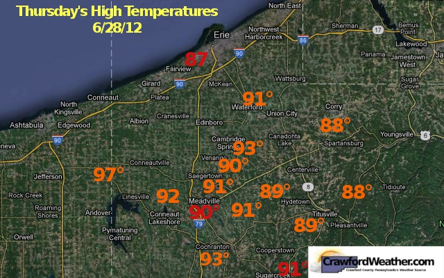
June 28, 2012
4th of July Fireworks

Fireworks:
Saturday June 30
Canadohta Lake
10:00 PM
Pymatuning State Park Dam - Jamestown, PA
Starting At Dusk
Centerville
Starting At Dusk
Sunday July 1
Movies at Meadville
10:00 PM
June 26, 2012
Fireworks Forecast
As the Fourth of July gets closer, I'll be listing the regions firework shows and also be giving a 'Fireworks' Forecast so make sure to check back!
June 20, 2012
Wednesday's Highs
The first day of summer proved to be well..."summer like" with very warm temperatures and high dew points. So how hot did it get? Here are the high temperatures around the region for Wednesday.
 |
| Graphic of Wednesday's high temperatures. The range was 84°-93°. Red numbers indicate official airport observations while the orange are from personal weather stations. Data from wunderground.com |
June 19, 2012
Summer Arriving Early

 Although Summer doesn't officially start until Wednesday evening at 7:09 PM, it'll feel alot like summer starting tomorrow as warm, moist air enters the region. Highs are expected to hit 87° here in Meadville but factor the amount of water vapor in the air and it'll feel alot more like the middle to upper 90s. It's only going to get hotter for Wednesday as highs are expected to reach 90° in Meadville and some places could even get up to 92°. It'll be another warm and humid day. Although I don't think we'll break the record for Tuesday (91°), we could tie or even break the record for Wednesday (90°). Thursday is looking warm and humid as well but a "slight" cool down will occur for Friday and Saturday as a weak front pushes through. Highs will be in the upper 70s. Not much expected in terms of precip. Could see a storm as the front pushes through Thursday evening but no wash out days in sight.
June 14, 2012
Webpage Updates
Some new things are coming to the website. Hopefully by the end of the summer (most likely earlier than that), I'll have all of these things done. Some of the new features coming:
- CrawfordWeather.com Photos
A chance for users to upload various pictures to CrawfordWeather.com to display them on the site.
- Regional Weather
Current conditions for areas outside of Crawford County but within the region. (Erie, Franklin..etc.)
- County wide temperature forecasts
I'm working on a weather model that will compute temperatures for many locations across the county. I'm still working on accuracy issues with it but it is coming along pretty well so far. There will be a high and low temperature map for various locations across the county.
- A smoother, more efficient webpage design.
This one will require the most work for me but my goal is to make things a little more professional looking. The overall design of the page won't change but some of the graphics might. Occasionally some of the things on the webpage tend to be out of whack with the rest of the site so my goal is to correct these issues.
- Morning Audio Forecasts
I'm planning on busting out the audio forecasts for the webpage. The plan is to have a audio player on the website where users can listen to a 1 minute forecast segment every morning detailing the weather for the day and night.
- Forecast Verification
I'll be posting forecast verification results so you can see how well (or how well I didn't do) for the month in terms of temperature accuracy.
Pretty long list of stuff to do. My plan is to have this all done before the end of the summer, and hopefully if all goes well, earlier than that. The earliest would be like mid July. I'm always up for suggestions for improving the website. If you would like to see something or don't like something that I have on here, send me a message at jordan@crawfordweather.com.
- CrawfordWeather.com Photos
A chance for users to upload various pictures to CrawfordWeather.com to display them on the site.
- Regional Weather
Current conditions for areas outside of Crawford County but within the region. (Erie, Franklin..etc.)
 |
| County wide forecasts are expected to be displayed on the website before the end of the summer. |
I'm working on a weather model that will compute temperatures for many locations across the county. I'm still working on accuracy issues with it but it is coming along pretty well so far. There will be a high and low temperature map for various locations across the county.
- A smoother, more efficient webpage design.
This one will require the most work for me but my goal is to make things a little more professional looking. The overall design of the page won't change but some of the graphics might. Occasionally some of the things on the webpage tend to be out of whack with the rest of the site so my goal is to correct these issues.
- Morning Audio Forecasts
I'm planning on busting out the audio forecasts for the webpage. The plan is to have a audio player on the website where users can listen to a 1 minute forecast segment every morning detailing the weather for the day and night.
- Forecast Verification
I'll be posting forecast verification results so you can see how well (or how well I didn't do) for the month in terms of temperature accuracy.
Pretty long list of stuff to do. My plan is to have this all done before the end of the summer, and hopefully if all goes well, earlier than that. The earliest would be like mid July. I'm always up for suggestions for improving the website. If you would like to see something or don't like something that I have on here, send me a message at jordan@crawfordweather.com.
Thurston Classic Forecast

Thursday June 14 @ 9 PM
Night Glow
Conditions: Mostly clear skies.
Launch Time Temp: 68°
Winds: Light, < 5 mph, ENE
Friday June 15 @ 6 PM
Sponsors Flight
Conditions: Mostly sunny.
Launch Time Temp: 77°-80°
Winds: Light, 5-10 mph, SE
Saturday June 16 @ 7 AM
Race #1
Conditions: Mostly Sunny.
Launch Time Temp: 59°-63°
Winds: Light, 3-7 mph, SSE
Saturday June 16 @ 6 PM
Race #2
Conditions: Mostly sunny.
Launch Time Temp: 78°-82°
Winds: Light, 5-10 mph, SSE
Sunday June 17 @ 7 AM
Race #3
Conditions: Partly cloudy.
Launch Time Temp: 62°-66°
Winds: Light to Moderate, 8-14 mph, S
For more information regarding this year's Thurston Classic...check out thurstonclassic.com
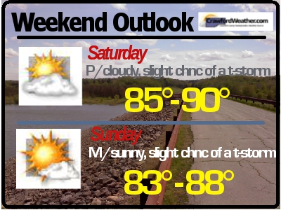
Weekend Outlook

Saturday will be mainly sunny all day. Sunday will start off mostly-to-partly sunny and clouds will increase later in the evening as a weak front approaches the area. Overnight Sunday could see some rain chances, depending on the strength of the front. Overall, it will be a pretty superb weekend to get out and do some yard work, tan, or just enjoy the summer like weather. Check out the Thurston Classic in Meadville if you have time. Have a great rest of the work week and weekend!
June 3, 2012

June 2, 2012
Tonight's Low Temps
I'm working on creating a weather model that will predict high and low temperatures around the county. The model is still in beta mode and will need a few minor tweaks but I'll be testing it out over the next couple of weeks. With that being said, here are tonight's lows as forecasted by my weather model. I have a feeling they might be a little too high but we will see.

Actual Lows:
Conneautville: NA
Conneaut Lake: NA
Meadville: 48
Cochranton: 50
Saegertown: 49
Woodcock: 50
Cambridge Springs: 49
Guys Mills: 49
Townville: 49
Titusville: 47
Spartansburg: 46

Actual Lows:
Conneautville: NA
Conneaut Lake: NA
Meadville: 48
Cochranton: 50
Saegertown: 49
Woodcock: 50
Cambridge Springs: 49
Guys Mills: 49
Townville: 49
Titusville: 47
Spartansburg: 46
Rainfall Totals June 1, 2012
 |
| Rainfall totals for June 1, 2012. Notice the strip of high precipitation amounts. This is due to a heavier rain band that was moving NNE. |
June 1, 2012
Venus Transit

http://www.usatoday.com/tech/science/space/story/2012-05-31/transit-of-venus/55320404/1

June Outlook
 |
| One month temperature outlook for June. According to the CPC, we will be about normal. Source: CPC |
 |
| One month precipitation outlook for June. According to the CPC, we will be about normal. Source: CPC |
Weekend Outlook

Subscribe to:
Posts (Atom)