
 |
| March 20 marks the vernal equinox where there is equal amounts of daylight and darkness. NWS CLEVELAND |
So people are wondering when is winter going to make its final return. It looks like its final return was weeks ago. The polar Jet Stream is showing no signs of moving south again in the short term and even the long term it says far north. A blocking high pressure area is set up over the Atlantic and is not budging so I expect warm temperatures to continue through the rest of the month.
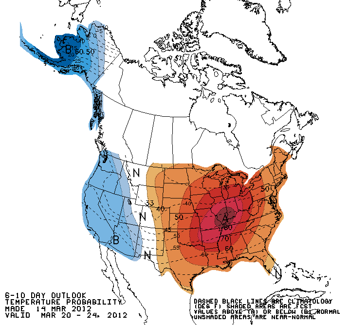 |
| 6-10 day temperature outlook. CPC |
 | |
| 8-14 day temperature outlook. CPC |
 |
| Temperature outlook for March. CPC |
Average Forecasted High For The Next 5 Days: 73°F
Normal High/Low for this time of year: 42°F/24°F
There is a good chance some records will be set.
Record Highs:
| March: | High | Year |
| 15 | 79 | 1990 |
| 16 | 80 | 1990 |
| 17 | 68 | 2003 |
| 18 | 67 | 1989 |
| 19 | 70 | 1966 |
Numbers from wunderground.com for Port Meadville Airport.
Forecasted High Temperatures for the next 11 days.
Smaller temperatures are AccuWeather Forecasted Highs.
| March: | High |
| 15 | 73 |
| 16 | 70 |
| 17 | 73 |
| 18 | 76 |
| 19 | 74 |
| 20 | 72 |
| 21 | 67 |
| 22 | 62 |
| 23 | 59 |
| 24 | 60 |
| 25 | 64 |
No comments:
Post a Comment