 |
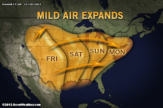
Milder temperatures will move in over the weekend
and into Monday.
Photo Credit: AccuWeather | | |
|
After our small and kind of disappointing lake effect snow event last weekend, things have quieted down. As the week comes to an end and the weekend begins to fall upon us, the weather pattern is looking fairly quiet with no large systems impacting our region in the near future. Friday there is a slight chance that our region could see a little bit of snow/rain mix. However right now it appears that most of the region will remain dry. Saturday will start out as dull but skies will clear towards evening. Temperatures will be gradually warming starting Saturday. Sunday a weak front will move through with only a chance for scattered rain showers. Temperatures will still be above average. Monday is looking unseasonably warm for the area and should be a decent day with some sun. Tuesday is when a stronger front makes its way through the region bringing with it some scattered rain showers. Behind it will be colder air that will bring temperatures back down to normal and slightly below normal. A few snow showers could spark up Wednesday but as of right now it appears to be minimal.
Looking even farther ahead, warmer temperatures appear to move back in late week and into the weekend out ahead of a front. However the front is expected to move through towards late weekend and behind it we could see a strong lake effect snow event. Realize it is over a week away and things are likely to change but just a heads up.


No comments:
Post a Comment